Islands and Shoreline
The islands are largely low leveled
flat-topped and generally rise to a height of a few metres above sea.
Occasionally old dunes on the sides of the
lagoons and storm beaches on the seaward side of the islands consist of a sandy
beach at places, beach rock is exposed at low tide mark. The eastern shore in
all the islands (except Kadmat, Agatti, Bangaram and Cheriyakara) is marked by storm
beaches, of coral pebbles and boulders piled up well above the high tide mark
by the storms from the east. The islands in the centre of the lagoon i.e.,
Bangaram and Cheriyakara and others have sandy bank on all sides.
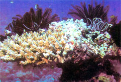 The islands are described as Coral Paradise because of scenic beauty. These
present a breath-taking spectacle of sparkling coral reefs encircling a placid
and tranquil lagoon and palm covered tiny islands. These islands not only have
their wealth of natural beauty but also present spectacular variety of animal
and bird life Lakshadweep is India's only Coral Paradise. The islands are described as Coral Paradise because of scenic beauty. These
present a breath-taking spectacle of sparkling coral reefs encircling a placid
and tranquil lagoon and palm covered tiny islands. These islands not only have
their wealth of natural beauty but also present spectacular variety of animal
and bird life Lakshadweep is India's only Coral Paradise.
The Lakshadweep group of islands lie on the northern edge
of the 2500Kms
long North-South aligned submarine Lakshadweep Chagos ridge. The ridge
is separated from the Malabar shelf by the Lakshadweep Sea and merges
with the shelf between latitude 11 to 14. The ridge rises from a depth
of 2000 to 2700 metres in the Lakshadweep Sea and about 4000mts in the
Arabian Sea. The eastern side of this ridge appear to be steeper than
the western. The ridge has a number of gaps, the main being the Nine Degree
Channel which separates the atoll of Minicoy from the northern group of
islands. On this extensive ridge a large number of atolls and some large
banks are situated.
All the islands are covered with white sand. A few metres under the sand on
all the islands; excepting Minicoy and Kalpeni, lies a horizontal bed of coral
lime-stone. The limestone is used for the construction of buildings. Plentiful
supply of potable water is available in this limestone layer. Fresh water can be
obtained by bore well through the limestone subtraction at an average depth of
two to three metres.
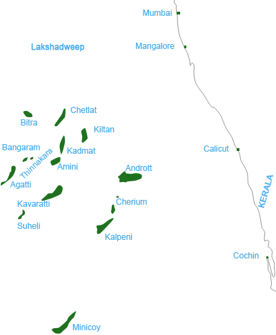
This archipelago consists of 12 atolls, three reefs and five
submerged banks. Of its 36 islands covering an area of 32Sq.Km only 10 are
inhabited. They are Adroit,
Amini,
Agatti,
Bitra,
Chetlat,
Kadmat,
Kalpeni,
Kavaratti
(Headquarters), Kiltan
and Minicoy.
| ISLANDS |
ISLETS |
| 1. Viringili |
Utturubilla |
| 2. Cherium |
|
| 3. Kodithala |
|
| 4. Tilakkam (i) |
Titakkam (ii) & (iii) |
| 5. Pitti (i) |
Pitti (ii) & (iii) |
| 6. Bangaram |
|
| 7.Tinnakara |
|
| 8. Parli (i) |
Parli (ii) & (iii) |
| 9. Kalpitti |
|
| 10.Suheli Valiyakara |
Indira Dweep |
| 11.Suheli Cheriyakara |
Shastri Dweep |
| 12.Pitty (Bird Island)
Chetlat
Bitra |
Gandhi Dweep
Nehru Dweep |
|
|