Thursday, March 28, 2024
Pondicherry

Area : 480sq.km
Capital : Pondicherry
Languages : Tamil, Telugu, Malayalam, English and French
Districts : 4
Population

:1,244,464 (2011 census)

Literacy :86.55%
State Bird : Asian Koel
State Animal : Squirrel
State Flower : cannon ball flower
State Tree : Vilvam
Pondicherry map

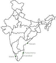
The Union Territory of Pondicherry extends from Latitude 11056' in the North to Longitude 79053' in the East. Pondicherry comprises four coastal regions namely Pondicherry, Karaikal, Mahe, and Yanam. Pondicherry 
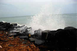
and Karaikal are situated on the East Coasts in Tamil Nadu, Yanam in Andhra Pradesh, and Mahe on the West Coast in Kerala. It is still not known that why, French and British limited their territories in the intermingling manner, making Pondicherry a peculiar case for territorial 
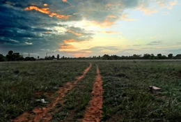
jurisdiction. Pondicherry more or less is a flat land with no hills and forests. Interspersed with parts of Cuddalore and Villupuram districts of Tamil Nadu, the Union Territory of Pondicherry presents a picture of scattered parts. Main soil types are red ferrallitic, black clay, and coastal alluvial.read more

Festivals
Colourful Puducherry
Pondicherry is an abode of temples dedicated to Lord Sulramaniar and various forms of ammans. International yoga festival held in January here is quite popular.
Fairs and Festivals
Festival Calendar
   
tourism
The city is renowned for its palm-fringed beaches, scenic fishing villages, Aurobindo Ashram, serene backwaters, French boulevard towns, and the international city of Auroville
About Puducherry
Tourist Information Centres
How to Reach There
   
Puducherry
The Union Territory of Pudhucherry this spiritual beach town used to be a French settlement comprising of Karaikal, Mahe and Yanam other than Pudhucherry itself.
History Classifieds
Economy Jobs
Land Yellowpages
Districts Government Directory