|
Mountains and Rivers
 The state is dotted with hill ranges from the north to the south, running
erratically down the middle of the country dividing it into western and
eastern or coastal Andhra. These hills form integral geographical entities
of Andhra life and history. In the north, there are Simhachalam and Annavaram
hills, in the middle country there are the Srisailam hill ranges and in
the south are the Tirumalai-Tirupati hills. The state is dotted with hill ranges from the north to the south, running
erratically down the middle of the country dividing it into western and
eastern or coastal Andhra. These hills form integral geographical entities
of Andhra life and history. In the north, there are Simhachalam and Annavaram
hills, in the middle country there are the Srisailam hill ranges and in
the south are the Tirumalai-Tirupati hills.
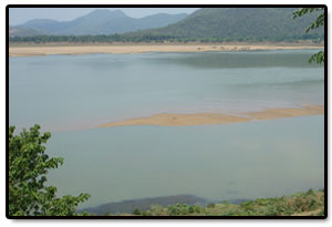
Nearly 75% of the state territory, is covered by the
basins of three big rivers - Godavari, Krishna and Pennar and their tributaries.
In addition, there are 17 short rivers like Sarada, Nagavali, Musi and
other streams. The two great perennial rivers of the state, Godavari and
Krishna spring from the Western Ghats in Maharashtra and flow eastward
and joins the Bay of Bengal. The Godavari enters the state of Andhra Pradesh
direct from Maharashtra, but the Krishna first goes to Karnataka where
it flows for a considerable distance before entering Andhra Pradesh.
Besides
these two big rivers, there are the Tungabhadra, the Pennar and many other
small rivers and rivulets. Pennar originates in the Karnataka plateau.
Like all the peninsular rivers and even those which arise in central India,
like the Narmada, Sone and Chambal, all these are rain fed rivers as there
is no snow below the Himalayas. Andhra Pradesh has considerable topographical
variations with dense forest in the north east, flat paddy lands in the
coastal plains, several noteworthy beaches along the Bay of Bengal and
the stark boulder-strewn region around Hyderabad.
|