|
|
Thursday, July 16, 2026
|
|


|
|||||||
|
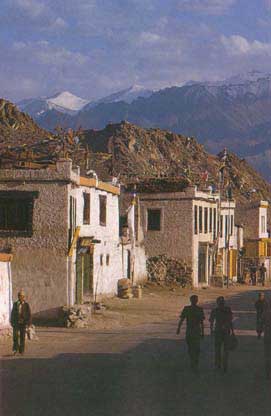
Ladakh
The province of Ladakh touches the Chinese border on the north, merges into Tibet in the east and is contained along the south by the extension of the great Himalayan range. The Karakoram range of mountain lies in the north Ladakh. The second highest peak in the world, K2 (Mt.Godwin 8611 metres) crowns one of its many tall mountains. The Karakoram pass (5,517.64 m) is situated towards the north-east of Karakoram, in an area where China, Tibet, and Ladakh meet. This pass facilitates a direct route from India to China. Until some years ago, Ladakh used to be the gateway to Tibet, connecting India with Tibet and east Turkistan. As such, it was an important trade centre, also being the meeting point of the Tibetan, Indian, Chinese, and Islamic cultures and traditions. Leh, the headquarter of Ladakh (3,521 m above the sea level) is a fascinating town built on a hillside and surrounded by rocky hills. It was once the commercial nerve centre of Central Asia just as Hong Kong is of the Far East. Traders thronged Leh from Turkey, Arab countries, Iran, and Afghanistan. Leh town is full of orchards, groves, gardens and monasteries and is crowded with people. Poplars and Willows are aplenty. Apples, apricots and giant-size melons are grown in these orchards. Ladakh is a mountainous terrain between the Himalayas and the Kuenlum mountains. One of the highest habitations in the world, Ladakh has an elevation ranging between 2,400 m and 4,500 m above the sea level. The average height of its mountain is between 5000 and 7000 m. Its valleys, about 500 sq km in area, lie along the headwaters of the Indus, the Sutlej, and the Chenab rivers. The Indus, having originated hundreds of kilometres further east from near the Kailash mountain and the Mansarovar lake in Tibet, flows in an almost straight line from north-west to the south-east of Ladakh. The river enters the region of Skardu in Baltistan.
In the north-east of Leh, at the town of Nyoma, lies an unusual terrain, where the colour of the soil and rocks is purple. The awe-inspiring mountain peaks seem to touch the sky. There is a conspicuous absence of life of any form and hence it has been aptly called the "Land of the broken moon", a truly poetical name.
Over the Ladakh range and in the north of Leh is the road to Khardung La (5,600 m above the sea level), the highest road in the world - a veritable walk over thick ice-sheets, ice-walls, and glaciers with the Karakoram range in the background . Further on, Chushul, the Pangong salt water lake, is about 112 km long. Its water is blue-green and sometimes indigo-purple. Kargil (about 2,750 m above the sea level) has a similar network of mountains around it. The people of Kargil do some farming and raise sheep. Their houses are built of stone and plastered with thick layers of mud to escape the extreme rigours of the cold. They profess Islam. The high altitude of Ladakh and Kargil and high mountains encircling the region give it a unique climate- absolute dryness (the annual rainfall is about 4 inches , i.e. 10 cm , and there is very little snow), arctic cold and extremes of weather. It is burning hot by day and piercing cold by night, very hot in summer, and extremely cold in winter. |
|||||||
|
||||||||||
|
||||||||||
Related Links |
| ▪ Government |
| ▪ Classifieds |
| ▪ Education |
| ▪ Yellowpages |
| ▪ Photo Gallery |
| Last Updated on : 21 May 2018 |

 Beyond
the valley of Kashmir, the inner Himalayas rising in the north and east
contain the frontier region of the state. The territory comprises the
three geographical divisions of Ladakh, Baltistan, and Dardistan.
Out of the total area of the state of 138,992.1 sq km, the district
of Ladakh (97,782 sq km) covers 70.4% of the total area .
Beyond
the valley of Kashmir, the inner Himalayas rising in the north and east
contain the frontier region of the state. The territory comprises the
three geographical divisions of Ladakh, Baltistan, and Dardistan.
Out of the total area of the state of 138,992.1 sq km, the district
of Ladakh (97,782 sq km) covers 70.4% of the total area .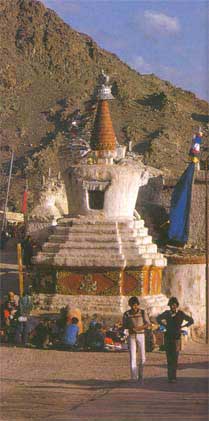 An interesting spectacle in Ladakh is represented by hot springs and geysers
roaring and throwing steaming hot water up to a height of 150 m and projecting
fantastic rainbow colours. These fountains of water represent phenomenon in
winter when the boiling water comes down in the shape of ice blocks with the
impact of chilly winds and form mounds next to the geysers.
An interesting spectacle in Ladakh is represented by hot springs and geysers
roaring and throwing steaming hot water up to a height of 150 m and projecting
fantastic rainbow colours. These fountains of water represent phenomenon in
winter when the boiling water comes down in the shape of ice blocks with the
impact of chilly winds and form mounds next to the geysers.