|
|
Friday, July 24, 2026
|
|


|
|||||||
|
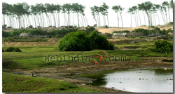
West Bengal has two natural divisions. The Himalayan north comprising the districts of Darjeeling, Jalpaiguri and Cooch Bihar and the alluvial plain that lies south of it. West Bengal is essentially a flat, featureless alluvial plain large portion of it being a part of delta of river Ganga, only one per unit of its area in the far north is really mountainous. The plateau fringe and the Purulia triangle of upland along her western border, comprises about six per cent of the total area. The northern part of the district of Darjeeling is hilly to mountanious. Its border to the north being fenced with rising mountain ranges of the Himalayas. Downwards, the mountains slope down to hills and as the borders of Jalpaiguri district are reached, the hills give way to rolling humid plains known as the Dooars. The Singalila range along the border with Nepal rises to nearly 3,700 metres, and is well wooded with rhododendron trees. The Dooars forests are densely wooded with evergreen vegetation and are the resorts of wild animal including the Royal Bengal tiger, rhinoceros, elephant, antelope and snakes including Python. The central region or the 'Malda Pouch' comprising the districts of Malda and West Dinajpur is geographically an older area than the Gangetic plains below. It has a slightly higher land level watered inter-mittently by hill rivers among which the Mahananda with its winding course is the largest. It pours into the Ganga a little above Farakka in Bangaladesh.
The southern region, starting in the north from the point where the Ganga demarcates in the boundaries of the districts of Malda and Murshidabad consists of two geographically distinct areas. "Western Plateau Fringe" consist of the Purulia district and the western part of the districts of Birbhum, Burdwan, Bankura and Midnapur. The highest point of this plateau, named Goraburu Hill in Purulia district is 677 metres and the lowest point is 85 metres above the sea level where the up land ends in Midnapur district on the northern bank of the Subarbarekha river the altitude falls to 50 metres above the sea level. The plateau forms the tail-end of the chhartisgarh state of Orissa and Madhya Pradesh. The rest of the southern region is a vast alluvial plain, except for the western plateau fringe and the sub-montane area of Darjeeling district, the entire length of West Bengal is one rolling up land. The vast alluvial plains of the state spread from Jalpaiguri and Siliguri in the north to the Sundarban creeks and its Kanthi littoral in the south. The southern region is bisected by the Bhagirathi (Hooghly)river, one of the two forks of the Ganga that take off from top of Murshidabad district. The plain land on the western bank of the Hooghly river is largely formed by the deposits carried by a system of hill rivers rising in the western hills that pour their waters into the Hooghly and form part of the Gangetic delta. The main river in this system is the Damodar, Bengal's 'River of Sorrow'. The plains to the east are watered by distributaries of the Ganga branching off in West Bengal as well as Bangladesh. One feature of these plains is the existence of shallow lagoons called 'dahas'or 'boonrs', formed by beds of distributaries that got silted up above and below and of low marsh lands called bells that become flooded during the rainy season.
The coastal fringe likewise is of two distinct characters, west of the Hooghly the coastal strip in Midnapur district called the Contai or Kanthi strip. It consist of sand dunes and salt marshes mingled with each other. The marshes are formed behind well-developed sand bars. At places there are large shifting sand dunes, which have a tendency to blow landwards and encroach upon the cultivated land behind them. Vistas of Casuarinas plantation are being developed all along the coast to fix the dunes and stop sea erosion. The Japanese quick growing creeper Kudzu is also being planted. The natural vegetation consists of clumps of Keya bushes. Their fragrant flowers are collected to produce the famous Kewra scent. The Sunderbans The Hooghly river estuary that covers the entire southern portion, nearly a fourth of the total area of twenty four Parganas district consist of the remarkable tropical forest called the Sunderbans. The major portion of this Sforest is located in the adjoining Bangladesh district of Khulna and Barisal. The region is entirely alluvial. It is crisscrossed by a network of naturally forming arterial streams branching off from the major waterways and almost wholly consist of swamps and morasses abounding in quick sands. Close to the sea-belts the jungles are thick and hardly penetrable on account of the boggy character of the soil and the treacherous-sharp pointed spikes of the Sundri (mangrove) trees. The Sunderbans are abound in royal Bengal tiger, leopard, rhinoceros, wild hog, deer, monkeys, python, different species of Cobra and other snakes and many varieties of birds. The rivers are abound in Crocodile, shark and many kinds of fish. The jungle prevent major erosion of the coastline, the tidal incursions of saline water from the sea and the torrential flow of water in the river during the monsoons cause frequent and considerable changes in the land area above the jungle fringe. Here is a constant war between nature and man for saving the rice producing agricultural land from being inundated by brackish water or being rapidly eroded by the sea. Huge earthen dykes are constructed around agricultural settlements called Chauks. The hinter land between the Damodar and the Hooghly and right up to the border of Bangladesh is served by dead or drying channels of the Hooghly. This area is called the Moribund Delta.
|
|||||||
|
| Tweet | |
|
||||||||||||||||||||||||
|
||||||||||||||||||||||||
| Last Updated on : 19th June 2025 |

 West Bengal was created as a constituent state of the Indian union on
15 August 1947 as the result of partition of the undivided British Indian
province of Bengal into West Bengal. West Bengal covers the bottle neck
of India in the east, stretching from Himalayas in the north to the Bay
of Bengal in the south. It is bounded on the north by Sikkim and Bhutan,
on the east by Assam and Bangladesh. On the south by the Bay of Bengal
and on the west by Orissa, Bihar and Nepal. It has therefore, three international
frontiers-to the north, east and west. The state lies between 27o13'15"
and 21o25'24" north latitudes and 85o48'20"
and 89o53'04" east longitudes.
West Bengal was created as a constituent state of the Indian union on
15 August 1947 as the result of partition of the undivided British Indian
province of Bengal into West Bengal. West Bengal covers the bottle neck
of India in the east, stretching from Himalayas in the north to the Bay
of Bengal in the south. It is bounded on the north by Sikkim and Bhutan,
on the east by Assam and Bangladesh. On the south by the Bay of Bengal
and on the west by Orissa, Bihar and Nepal. It has therefore, three international
frontiers-to the north, east and west. The state lies between 27o13'15"
and 21o25'24" north latitudes and 85o48'20"
and 89o53'04" east longitudes.