|
|
Thursday, July 23, 2026
|
|


|
||||
| Kerala is a small state, tucked away in the south west corner of India. It represents only 1.18 percent of the total area of India but has 3.34% of the total population of the country. It is separated from the rest of the peninsula by natural geographic boundaries. 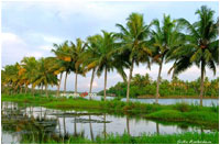
Kerala may be divided into three geographical regions (1) high land (2) mid land (3) low land. The high lands slope down from the Western Ghats, which rise to an average height of 900m, with a number of peaks over 1,800 m in height. This is the area of major plantations like tea, coffee, rubber, cardamom and other species. The mid land lies between the mountains and the low lands. It is made up of undulating hills and valleys. This is an area of intensive cultivation - cashew, coconut, areca nut, cassava, banana, rice, ginger, pepper, sugarcane and vegetables of different varieties are grown in this area. The 'Western Ghats' with their rich primeval forests having a high degree of rainfall, form the eastern boundary and extend from the north to Kanyakumari in the south. The entire western border is caressed by the Arabian sea. Between these natural boundaries lies the narrow strip of land extending from Kasargode in the north to Parasala in the south. The south-west and north-east monsoons with their accompanying downpour keep the land soaked, for a period of five to six months in a year. The 'western Ghats', which form the eastern ramparts of the state rise from very low altitudes of a few hundred metres upto about 2,000 metre on an average.
The 'Anamudi' peak in the high ranges of Kottayam district rises to a height of 3,000 metres and represents the highest point in India, south of Himalayas. 'Agastyakutam' the southern most peak in the Ghats, is 2,044 metres. 'Ezhimala' is a rugged hill jutting into the sea in startling isolation on the Kannur coast. Ghats are served as an effective rampart. The range has many passes which have allowed a controlled interaction between Kerala, and the lands lying beyond the mountains. The 'Peranbadi Ghat' provides access to Coorg, the 'Periyar Ghat' to the Nilgiri district. The Palghat pass, 32 km broad, has played a bigger role in the alarums and excursions of history. In south, the Bodinaikannur pass connects Devikulam and Munnar in Kerala with the Madurai district of Tamil Nadu. Other passes linking Kerala with Tamil Nadu are Thevaram, the Kambam, the Kumili and the Aramboly. |
||||
|
|
||||
|
||||||||||||||||||||||||
|
||||||||||||||||||||||||
| Last Updated on : 30 May 2025 | ||||||||||||||||||||||||