|
|
Tuesday, January 6, 2026
|
|


|
||||||
Manipur is situated between
23.83oN and 25.68oN latitude and 93.03oE
and 94.78oE longitude. It comprises 1820sq.km of flat plateau
of alluvial valley There are many mythical stories about the origin of the name Manipuri. Some local people narrate its link with the Mahabharata. They say the name is from Mani, a jewel. This jewel was formerly in the possession of the Rajas of the country ages ago. The country was at one time named Mohindrapore but the Raja named Bubra Baha changed the name to Manipur. According to the Mahabharata the name Manipur was in existence before the birth of Bubra Baha and Mahindrapore was the name of a high hill which is situated a short distance to the east of the capital. Jawaharlal Nehru described Manipur as the 'Jewel of India'. By virtue of its geographical situation, Manipur is a shining pearl in the Himalayan system. Manipuris call it as Meithei Leipak. In the valley Kongba (Imphal), Eeril and Thobal are the big rivers which originate from the hills and flow down into the valley and forms the drain for all waters flowing into the valley carrying them off by Sagnu river through the southern ranges of hills further into the Ningthee. The Bark river flows through its western borders. The natural lake Loktak is a big water reservoir of 36 metres depth. It is 8 miles long from north-west to south-east and 5 miles broad at its greatest breadth from the east to west. The dark green Eichornia (water Hyacinath) reed and other aquatic plants floats on its surface abundantly.
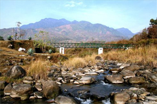
In the valley there are numerous small lakes and swamps. The hillsaround the cup-shaped valley add to the natural beauty of Manipur. The hills are part of the Himalayas andare termed as Sub-Himalayan ranges. They are spread into rangeswith irregular serrated ridges with tapering cliffs. There are several names given to these ranges. On the west : Nunjaibong, Kala Naga, Chakka Nungba, Kanpum and Kopru-Laimotol. On the north : The Khhunho spurs, Thumion (Mayang Khang), Laison and Sirohi farar. On the East : Surameti or Chinganguba, Somrah, Kassom, Nupitel or Maphitel and Yomadoung and on the South : Hawbi. Among these Chinganguba or Surameti peak is the highest with 12,557ft. All the hills are covered with luxuriant growth of forests with nagesar, jurul, India-rubber, tan, oak, ash, teak, palm (in eastern slsopes). There are different varieties of bamboo all over Manipur. Pinus Longifolia is found in Somrah basin and in northern portion. It has been planted on the hillock adjacent to Imphal town. The forest department of Manipur should make it a policy of reforestation of these entire ridges if they are really keen on aesthetic reflection of Imphal town in its peripheries. In the high hills the red and white rhododendron is seen. The flame of the forest trees are also found on the way to Tamenglong. The soil is considered fit for all kinds of grain crops, vegetables and fruits. Sirohee hill in Ukural is famous for the Sirohee lily. The species of this plant is endemic to that particular hill only. |
||||||

 and
20507sq.km of hill territory and forms a part of the Himalayan mountain
system which carries this cup-shaped wonderland inside its series of hill
ranges. Manipur is bounded by Nagaland in the north, Mizoram in the south,
upper Myanmar in the east and Cachar district of Assam in the west. The
valley portion of the state is surrounded by hill ranges from all sides.
and
20507sq.km of hill territory and forms a part of the Himalayan mountain
system which carries this cup-shaped wonderland inside its series of hill
ranges. Manipur is bounded by Nagaland in the north, Mizoram in the south,
upper Myanmar in the east and Cachar district of Assam in the west. The
valley portion of the state is surrounded by hill ranges from all sides.