|
|
Wednesday, December 3, 2025
|
|


|
||||
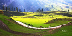
Geographically, the Jammu and Kashmir state is divided into four zones. First, the mountainous and semi- mountainous plain commonly known as Kandi belt, the second, hills including Siwalik ranges, the third, mountains of Kashmir valley, and Pir Panjal range and the fourth is Tibetan tract of Ladakh and Kargil. The Kashmir valley enjoys an enchanting climate for the major part of the year. A unique feature of the climate is the four clear-cut seasons - spring, summer, autumn, and winter. Till the end of May, the climate of Kashmir is comparable with that of Switzerland. In spring, the valley wears blankets of emerald green grass and is decked with flowers of various hues and fresh leaves - a phenomenon of rejuvenation from the rigors of a long winter. It is then the worlds' most wonderful of natural gardens. In summer, the sleepy blue mountains with snow-capped peaks, clear streams, cool bubbling springs, noisy torrents, beautiful lakes, shady chinar groves, silvery poplars, drooping willows, and pine forests make Kashmir the "play ground of Asia." In autumn, the trees and forests turn into bronze and copper colours, and the foliage becomes a riot of golden yellow and green. In winter, the giant size trees wear a bare look when the landscape dons a mantle of snow.
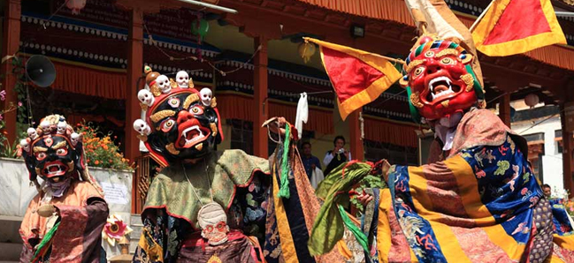
The population of the state, according to the 2011 census was 12,548,926 (6,665,561 males and 5,883,365 females) - this figure excludes the areas under the occupation of Pakistan and China. According to the projections made by the standing Committee Of Experts On Population Projections, October 2001, the population of the state was 10,143,700. The 1991 census could not be held due to disturbances in the state. The density of population as given by this Committee is 76 persons per sq km. The decimal population growth rate for 2001-11 was given as 23.71 % as against 29.43 % for the period 1991-2001. The religion-wise breakup of the population as per the 2001 census showed that the Muslims constituted the predominant religious community of the state at 67.0% , Hindus came next at 29.6%, Sikhs 2.23%, Buddhists 1.16%, Christians 0.14 %, and others form the remaining part. |
||||
|
|||||||||||||||||
|
|||||||||||||||||
Related Links |
| ▪ Government |
| ▪ Classifieds |
| ▪ Education |
| ▪ Yellowpages |
| ▪ Photo Gallery |
| Last Updated on : 21 May 2018 |

 One of the largest states of the Indian union, Jammu and Kashmir covers an area
of 2,22,236 sq km. This includes 78,114 sq km under illegal occupation of
Pakistan, 5,180 sq km handed over by Pakistan to China, and 37,555 sq km under
occupation of China.The state lies between 32o
17' to 36o 58'
North latitude and 73o 26'
to 80o 30' East
longitude. From North to South, it extends over 640 km and from East to West, 480
km. It occupies the North-West niche of India, bounded on the South by
Himachal Pradesh and the Punjab, on the South West and West by Pakistan, on
the North by Chinese Turkistan and a little of Russian Turkistan, and on the
East by Chinese Tibet - thus strategically bordering the territories of
three countries - Russia, China, and Pakistan. The State capital is
Srinagar in summer and Jammu in winter.
One of the largest states of the Indian union, Jammu and Kashmir covers an area
of 2,22,236 sq km. This includes 78,114 sq km under illegal occupation of
Pakistan, 5,180 sq km handed over by Pakistan to China, and 37,555 sq km under
occupation of China.The state lies between 32o
17' to 36o 58'
North latitude and 73o 26'
to 80o 30' East
longitude. From North to South, it extends over 640 km and from East to West, 480
km. It occupies the North-West niche of India, bounded on the South by
Himachal Pradesh and the Punjab, on the South West and West by Pakistan, on
the North by Chinese Turkistan and a little of Russian Turkistan, and on the
East by Chinese Tibet - thus strategically bordering the territories of
three countries - Russia, China, and Pakistan. The State capital is
Srinagar in summer and Jammu in winter.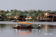 Kashmir
is a land of lakes and rivers. The river Jhelum (ancient name, Vitasta-
transformed into Veth, in Kashmiri parlance) meanders through the valley in
artistic Zigzags, which have furnished the motifs to the deft Kashmiri artisans.
Nestled among hills in the north-east of the valley is the Wular (20 km by 8
km), the largest fresh-water lake in India. The Dal lake, well known for the
Mughal gardens flanking it, in the vicinity of Srinagar, is about 6 km long and
about 3 km broad. Other well-known lakes are the Manasbal (the deepest in
Kashmir), the Kaunsar Nag (3,901.44 m), and the Gangabal and other mountain
tarns, at an elevation of over 3,300 m. In the Lidder valley, there are huge
glaciers like Kolahai which is about 8 km long and comes down as low as 3,300
m. The mountains and lakes are complemented by luxuriant orchards dotted
with majestic chinar trees, providing so many breathtaking spectacles.
Kashmir
is a land of lakes and rivers. The river Jhelum (ancient name, Vitasta-
transformed into Veth, in Kashmiri parlance) meanders through the valley in
artistic Zigzags, which have furnished the motifs to the deft Kashmiri artisans.
Nestled among hills in the north-east of the valley is the Wular (20 km by 8
km), the largest fresh-water lake in India. The Dal lake, well known for the
Mughal gardens flanking it, in the vicinity of Srinagar, is about 6 km long and
about 3 km broad. Other well-known lakes are the Manasbal (the deepest in
Kashmir), the Kaunsar Nag (3,901.44 m), and the Gangabal and other mountain
tarns, at an elevation of over 3,300 m. In the Lidder valley, there are huge
glaciers like Kolahai which is about 8 km long and comes down as low as 3,300
m. The mountains and lakes are complemented by luxuriant orchards dotted
with majestic chinar trees, providing so many breathtaking spectacles.