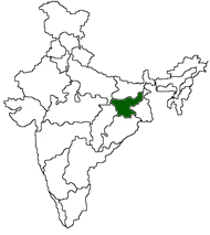
The state of Jharkhand
formerly a part of Bihar state, was formed on November 15th, 2000. Jharkhand
is the 28th state of the Indian Union. It is bounded by West Bengal in the
east, Uttar Pradesh and Chhattisgarh in the west, Bihar In the north and Orissa
in the south. The districts are Garwa, Palamu, Chatra,
Koderma, Hazaribagh, Giridih, Deoghar, Dumka, Godda, Pakur, Sahibganj, Dhanbad,
Bokaro, Ranchi, Lohardagga, Gumla, West Singhbhum and East Singhbhum. Ranchi
is the capital. Further details under construction..


 The terrain is intersected by the river Daman-Ganga and its three tributaries. The river rises in the ghat 64km from the coast and discharges itself in the Arabian Sea at the port of Daman