|
|
Friday, May 3, 2024
|
|


|
|||||
A part of Madhya Pradesh has been separated and formed into a new state Chattisgarh from November 1, 2000. The details given here are before the separation. Click on Chattisgarh for more information.
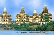
Except for the valleys of the Narmada and the Tapti, Madhya Pradesh consists of a plateau with a mean elevation of 1600 ft above sea level, interspersed with the mountains of the Vindhya and the Satpura ranges. The main river systems are the Chambal, Betwa, Sindh, Narmada, Tapti, Mahanadi and Indravati. Nearly a third of the state's area is covered with tropical forests ranging between the rivers Chambal in the north and Godavari in the south. To the east of Chambal, the area has rocky surface and thick forest. Farther north, the topography of the plains stretches up to the ravines of Chambal. The highlands of Malwa present an appearance of waving fields of grain and the green luxuriance among the shades of mango and tamarind trees clustering round the rural habitations. The inhabitants of this plateau are mostly agriculturists. The low lying area in the north of Malwa which touches the tract around Gwalior has a different appeal. Its north-east side gradually extends to y Bundelkhand and meets the Kaimur Hills in Baghelkhand. Here the people are more sturdy and of lesser height as compared to the peasants of Malwa. The hilly regions fall mainly on the Vindhya and Satpura ranges where Bhils, Gonds, Korkus and other tribes of mixed descent practice agriculture. The river Narmada which rises from Amarkantak begins to run through a rocky bed near Jabalpur and Mandla. It emerges near Mandhata and widens its flow near Maheshwar in Nimad. During the rainy season a rich growth of vegetation is visible all around. The black soil of Malwa bears magnificent crops. The climate is extreme in the north of Madhya Pradesh. It is cool and breezy in the central parts and humid in the eastern and southern regions. |
|||||

 Madhya
Pradesh situated in the centre of India, is surrounded by Maharashtra and
Andhra Pradesh in the south, Uttar Pradesh and Rajasthan in the north, Bihar
and Orissa in the east and Gujarat in the west. The state of Madhya Pradesh
came into existence on November 1, 1956.
Madhya
Pradesh situated in the centre of India, is surrounded by Maharashtra and
Andhra Pradesh in the south, Uttar Pradesh and Rajasthan in the north, Bihar
and Orissa in the east and Gujarat in the west. The state of Madhya Pradesh
came into existence on November 1, 1956.