INDIA
- Land
Mountains
| Rivers | Geographical
Divisions | States
 The
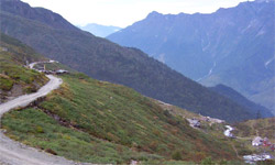
territory of India, represents a geographical amalgamation of various features
with its mountain
ranges, valleys, desert regions, tropical rain forests, fertile plains, dry
plateaus, coastal areas etc. The
territory of India, represents a geographical amalgamation of various features
with its mountain
ranges, valleys, desert regions, tropical rain forests, fertile plains, dry
plateaus, coastal areas etc.
The largest democracy
in the world, the land also known as Bharat or Hindustan is unique with
its incredible diversity, both culturally and physically.
Area
India,
is the seventh largest country in the world extending over 3, 287, 263 square
km. and occupies a strategic location on the Asian continent. The land extends from 8o4'
to 37o6 north latitudes and from
68o7 to 97o25 degrees east
longitude. India measures 3,214 kilometers from north to south and 2,933 kilometers
from east to west. The length of the coastline of the peninsula and the
two islands-Andaman and Nicobar and Lakshadweep together is 7, 516.6km.
Boundaries
The Indian
peninsula in the south is bounded on the west by the Arabian
Sea, on the east by the Bay of Bengal and on the south by the Indian Ocean. Sri Lanka lies off the southeast coast, and
the Maldives off the southwest coast. In the north, north east and
north west of the subcontinent lie the Himalayan ranges. India shares borders to the northwest
with Pakistan, to the north with China, Nepal and Bhutan, and to the east with
Bangladesh and Myanmar.
|
|
|


